About the Project
RES is in the early stages of investigating the feasibility of a wind farm proposal located southwest of the village of Llangurig in Powys.
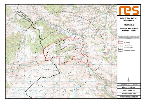
Click on the image below to see the site location and preliminary layout. Please note that the layout is subject to change as the project progresses.
Based on our initial studies, the wind farm would comprise of up to 35 turbines with a tip height of up to 230m, resulting in an overall site generating capacity of 252MW. This is enough to power approximately 270,0001 homes with clean, low-cost electricity every year.
At this early stage, we have recently submitted a Scoping Report to Planning and Environment Decision Wales (PEDW) to seek feedback on the proposed scope of environmental work whilst we continue conducting our site-specific surveys.
You can view or download a copy of the Scoping Report by clicking on the links below:
- Scoping Report
- Figure 1.1 - Site Location and Context Plan
- Figure 3.1 - Environmental Designations Plan
- Figure 3.2 - Lluest Dolgwiail Turbine Layout Plan
- Figure 5.1 - Landscape Designations and National Landscape Character
- Figure 5.2 - Turbine Blade Tip Height (230m) Zone of Theoretical Visibility (ZTV)
- Figure 5.3 - Turbine Hub Height (149m) Zone of Theoretical Visibility (ZTV)
- Figure 5.4 - Environmental Designations
- Figure 5.5 - Other Wind Energy Developments
- Figure 6.1 - Designated Heritage Assets
- Figure 6.2 - Historic Landscape Areas
- Figure 6.3 - Designated Heritage Assets within Zone of Theoretical Visibility (Turbine Blade Tip Height 230m)
- Figure 6.4 - Historic Assets with the Potential to Experience Effects from Proposed Development
- Figure 7.1 - Pond Locations
- Figure 7.2 - Designated Sites
- Figure 7.3 - Priority Habitats
- Figure 8.1 - Survey Area with Vantage Point Survey Locations
- Figure 8.2 - Breeding Wader Territory Locations (2024)
- Figure 8.3 - Red Kit Breeding Locations
- Figure 8.4 - Peregrine and Merlin Breeding Locations
- Figure 9.1 - Peat Depth
- Figure 11.1 - Public Rights of Way
The Scoping Report and supporting information are also available on the Planning and Decisions Wales (PEDW) website here using the reference number: DNS CAS-03962-R9F3F2.
1The homes figure has been calculated by taking the predicted annual electricity generation of the site (based on RES assessments Lluest Dolgwiail has a predicted capacity factor of 40.2%) and dividing this by the annual average electricity figures from DESNZ (Department for Energy Security and Net Zero, formerly BEIS) showing that the annual UK average domestic household consumption is 3,239 kWh (Jan 2024).
If you require Welsh translation of the website content, please contact us.
Os hoffech gyfieithiad Cymraeg o gynnwys y wefan, cysylltwch a ni.
Os hoffech gyfieithiad Cymraeg o gynnwys y wefan, cysylltwch a ni.